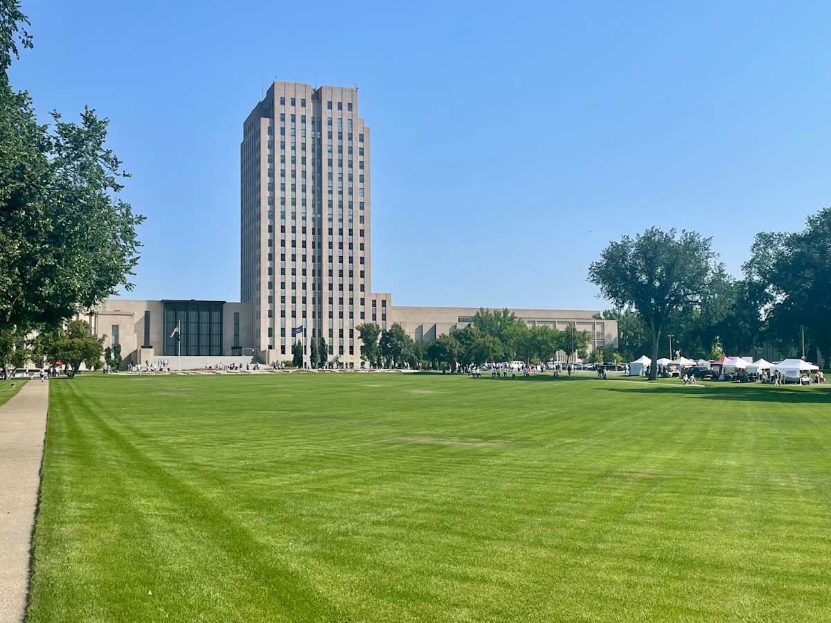
In my previous post I outlined the “road trip” that my wife and I took during the summer of 2026. In this post I will describe the trip in more detail “day by day.”
I should note that one can drive from Omaha, Nebraska to Bismarck, North Dakota, in 8 hours and 29 minutes (per Google, along Interstates 29 and 94). Even taking the more circuitous route that we took, avoiding the interstates, takes only nine hours and 24 minutes. So, by taking three days to get to Bismarck, we were demonstrating a fundamental aspect of our “road trip” theory – “slow and easy.”
Note: The photograph accompanying this post shows the state capitol of North Dakota. As such, it represents the state. I lived within a mile of this building for six years of my life. I previously posted a picture of the capitol on November 21, 2025 – “The Meyer Broadcasting Company (KFYR-TV).”
DAY 1 – Omaha to Valentine
The goal of the first day was to get about halfway to Bismarck, and Valentine was the town that best matched that goal. Valantine is located on the beautiful spring-fed Niobrara River, which runs west to east across the northern border of Nebraska. I had stayed in Valantine before. After biking/driving along the Cowboy Trail back in 2008, I tubed down the Niobrara River from Valentine (Smith Falls) to the Rocky Ford Landing.
To get to Valentine, we drove along US-275 and US-20 through Fremont, Neligh, Norfolk, and O’Neill. To a certain extent I was re-living my previous trip along the Cowboy Trail. During my 2008 trip, I spent nights in Neligh and Long Pine. During this year’s trip, we stopped at both of those towns to check things out (the historic Neligh Mill in Neligh; and “Hidden Paradise” and the “Bunkhouse” in Long Pine).
“Hidden Paradise” is a cabin-lined canyon that drops from the high plains into a green meadow. The Long Pine River winds through the narrow canyon. It has become a popular spot for tubers. The scenery and temperature change drastically is a matter of feet (thus paradise on a hot summer day), and the entrance to the canyon is somewhat hidden. You have got to know where “the” road into the canyon begins. It is a unique attraction in the state, unknown to most.
On my 2008 trip along the Cowboy Trail, I also spent one evening at the “Bunkhouse.” It was a railroad building that Long Pine had converted into “communal lodging” for bicyclists on the Cowboy Trail. Back in 2008 you had to, per instructions, first stop at a local tavern to pick up a key for the bunkhouse. Nobody apparently told the bartender on duty that day, so it took a bit of time just to find a key for me.
The bunkhouse was simple – a common living room and kitchen, a single bath, and twelve or so small rooms for the guests. I may or may not have been the only guest that night. No one else was there when I locked myself in my room at night, and no one else was there when I came out in the morning BUT there were some strange noises, one of the most uncomfortable evenings of my life.
The big stop that morning was a visit to the Johnny Carson wing of the Elkhorn Valley Museum in Norfolk, Nebraska. Johnny, born in Iowa, grew up in Norfolk and he retained a relationship with the town throughout the years, returning once to film a TV special “Johnny Goes Home.” The museum had a nice collection of Carson artifacts, including many of his awards and a re-creation of his Tonight Show set (complete with old jokes on old cue cards). As I have noted before (my blog post on January 23, 2026), Johnny was my “savior” during my former TV days. I enjoyed the museum.
Dinner that night was at The Prairie Club, a 46-hole golf complex (complete with a clubhouse, lodge, and cabins) which was located along the Snake River 20 miles southwest of Valentine off NE-97. The Prairie Club is one of many “destination” courses that have opened in the Nebraska Sandhills over the past twenty or so years.
· The Prairie Club’s fine-dining room overlooked the 18th hole of the Pines Course, which meanders to the south, through the pines, and along the canyon rim of the Snake River.
· The 18-hole Dunes Course winds its way through the sandhills, blow outs, and grasses to the east of the clubhouse.
· The unique 10-hole Horse Course was northeast of the clubhouse. Per the club’s brochure, “Innovatively designed to mimic basketball’s game of ‘horse,’ there are no tee boxes on this twelve-acre short course. Let your imagination go wild.” The yardages on the card were listed as being from 485 to 1125 yards (yikes!).
My wife liked her steak, the trimmings, and the ambiance. We were off to a good start. Back to the Harmony Inn & Suites in Valentine. Day One was over.
DAY 2 – Valentine to Selby
The goal of the second day was to get closer to Bismarck – close enough to drive into Bismarck early on the following day to pick up my sister at the Bismarck Airport at 11:16 AM (Allegiant Flight #24). Selby, a couple of hours south of Bismarck, proved to be the best place to spend the night. The drive was very simple, US-83 all the way.
Before leaving Valentine, we drove down to the Cornell Dam/Bridge on the Niobrara River and watched some tubers launch.
US-83 took us into South Dakota and the Rosebud Indian Reservation. We stopped briefly at the Sicangu Akicita Owicahe Tribal Veterans Cemetery, which was situated on a lonely prairie hilltop just to the east of US-83. From there we drove north through the Fort Pierre National Grassland (where Kevin Costner filmed Dancing with Wolves) to South Dakota’s capital city Pierre (pronounced “pier” like a boat dock, not “Pierre, like the classic French name). We drove by the beautiful South Dakota capitol building and nicely landscaped grounds.
We also visited Gavins Point Dam, just north of Pierre. Gavins Point was the third dam built along the Missouri River – in the middle of the twentieth century. Fort Peck Dam (Montana) and Garrison Dam (North Dakota) were the first two dams built on the Missouri River, and my father worked on both of those projects. The layout of Gavins Point Dam was very similar to the layout of Garrison Dam. The intake structure, spillway, and power plant reminded me of Garrison Dan and Riverdale, North Dakota.
I almost lived in Pierre. When Garrison Dam was completed around 1960, my father had to decide if he wanted to stay with the Corps of Engineers and transfer to the next job down the river, which was Gavin’s Point near Pierre. My dad chose to retire early and remain in North Dakota. Such are the decisions that impact one’s life.
From Pierre, it was straight up US-83 to Selby and “The Trail Inn & RV Sites.” The Trail Inn proved to be the most unique lodging we experienced on our trip. To start with, there was no resident desk clerk. To register I pushed a button and spoke with someone somewhere on a monitor. After I registered, a little door flipped open in a nearby box of keys, and there was the key to our room. If you are familiar with the concept of “Bath Fitter” and modular cruise ship staterooms, you could appreciate our unit at The Trail Inn – very compact, clean, and mostly plastic.
After checking in at The Trail Inn we were off to dinner in nearby Mobridge (the only bridge over the Missouri River and Oahe Reservoir). A generous serving of ice cream at Mr. Bob’s in Selby ended Day 2.
DAY 3 – Onto Medora via Bismarck
The goal of the third day was to get to the Bismarck Municipal Airport by 11:16 AM CDT to pick up my sister before heading down Interstate-94 to Medora to attend a 7:30 PM MDT performance of the Medora Musical.
From Selby we first headed north on US-83 and west on SD-10 to Pollock, South Dakota. Driving into Pollock, I was impressed by its very wide streets, unusual for a small town. I found out later that when Lake Oahe was filled, the former city (plotted in 1901) was inundated by the Missouri River. Before that happened, the residents of Pollock voted to move the town up the hill. With the help of the US Army Corps of Engineers, the town was relocated and replotted – with its extra wide main street.
From Pollock we then headed north on SD-1804, which after a few miles changed into ND-1804. The “1804” highways run parallel to and just to the east of Lake Oahe. The lake is not very wide, but it is quite long, stretching from just north of the South Dakota state capital in Pierre to just south of the North Dakota state capital in Bismarck. The roads flowed back and forth, up and down, but never very far away from the lake shore. This section of road, in terms of scenery, was #1 on this road trip.
Our timing was very good. We drove into the short-term parking lot at the Bismarck airport at the same time as Allegiant Flight #24 (from Las Vegas) landed. We quickly scooped up my sister and were on our way to lunch at the Walrus in Bismarck. On the way, we took two very short side trips to view 310 S 10 Street (where my grandparents once lived) and 710 N 13th Street (where my sister and I grew up).
We were soon zipping west on I-94 at the posted 80 mph, quite a change from the lower speeds that we had driven on the secondary roads. Somewhere along the way we crossed the Mountain/Central time zone line – gaining an hour. As we approached Medora, a slow rain started to fall, which lasted for several hours.
As we drove along I-94 in western North Dakota we would occasionally see oil rigs pumping away along the road. More oil is currently being produced in North Dakota than any other states, except Texas and New Mexico. Those oil wells, part of the Balken field, have caused the cities of Dickinson (along I-94) and Willistown (to the north) to “boom.”
Because of the rain, we decided to stay indoors (in the car) and drove the 36-mile scenic loop through the “South Unit” of Theodore Roosevelt National Park. From the park’s entrance in downtown Medora, we started the loop, first driving by several prairie dog towns. We (dry) peered at the prairie dogs (wet) peering at us.
After passing Skyline Vista, we dropped down into the Little Missouri River valley before starting the scenic loop. We slowly drove clockwise past Peaceful Valley Ranch, Boicourt Overlook, Badlands Overlook, and Scoria Point Overlook, before getting back to our starting point. Because of the rain, the colors of the Badlands were muted but the views were still stunning – so unlike the flat farmlands and rolling ranch lands we had seen east of Medora. Because of it “national park” status, no oil wells are in the park – but they hug the park border in some places.
After the drive, we stopped at the park’s visitor center and viewed Roosevelt’s Maltese Cross Cabin, where he once lived.
After the park, we scouted out the area, finding the Burning Hill’s Amphitheatre (where we would later view the Medora Musical), and the site of the recently opened Theodore Roosevelt Presidential Library – before stopping downtown to shop and kill some time – hoping for the rain to stop so that the outdoor musical would take place.
Thankfully the rain stopped about an hour before the show was scheduled to begin. The rain had cooled the air dropping the temperature into a more comfortable range. The musical staff hustled to wipe down the seats and the musical began on time.
Note: I wrote about the Medora Musical in a previous post (September 6, 2026).
After the musical, we drove back (30 miles) to our hotel in Dickinson. In the morning we would be returning to Medora to view the Theodore Rooswevelt Presidential Library. Day 3 had ended.
Day 4 – Library and Reunion (Day 1)
The goal of the fourth day was to visit the Theodore Roosevelt Presidential Library beginning at our ticketed 10 AM time slot and then get back to Bismarck in time for the first of my high school reunion dinners.
The Theodore Roosevelt Presidential Library was new. After a visit from President Trump, the library was opened to the public on Independence Day 2026. We were (correctly) concerned that tickets might be difficult to secure, so we had purchased our tickets in advance (before Trumps visit and opening day). We had three tickets for a 10 AM entry.
So, after breakfast at our hotel in Dickinson, we drove I-94 back to Medora, arriving slightly before 10 AM. We visited the library for about four hours.
Note: I wrote about the Theodore Roosevelt Presidential library in a previous post (August 30, 2026).
After eating a snack at the library, we took I-94 back to Bismarck and checked into Everspring Suites around 4 PM. We had lost a “time-zone” hour as we returned to Bismarck. I had also messed up the starting times for the reunion activities at the Bismarck Municipal County Club (5:00 PM register/social with dinner at 6:00 PM). Alas, we had to hurry to get to the club by 6:15 PM, slipping into the end of the buffet line – better late than never.
Note: I wrote about my “last” high school reunion in my previous post (September 13, 2026)
DAY 5 – In Bismarck
Saturday was the only day of our road trip that we were not on the road. The two main goals of the day were to lunch with relatives before attending the second high school reunion social/dinner that evening.
The reunion committee (for both Bismarck High School and St. Mary’s Catholic) had arranged a tour of the “new” St. Mary’s Central High School and the associated Our Lady of Victory Chapel at 10 AM Saturday (with coffee and donuts).
The reunion committee also (intentionally) scheduled the reunion to be held the same weekend as the city hosted the 52nd annual edition of the Capital A’Fair (an art fair on the state capitol’s mall), complete with a variety of craftsmen, artisans, food vendors, and a vintage car show.
As we had plans for the afternoon, we chose to go to the A’Fair in the morning and walked the grounds of the mall from 10 AM until noon, buying a few things along the way.
At 12:30 PM, my Aunt Arlene hosted a party for my sister, my wife, and me at A&B Pizza. Also attending were her three children (my cousins), a fourth cousin, other relatives (spouses) and friends. We had a good-sized section of the restaurant reserved for our group. The thin-crust pizzas kept coming and they were delicious. The company was also great. After the pizza, we headed over to my aunt’s home and enjoyed a variety of desserts and some more conversations.
At 5 PM, we headed to the Bismarck Elks Club for a second social and dinner. We got there on time.
Note: I wrote about my “last” high school reunion in my previous post (September 13, 2026).
DAY 6 – Back to Valentine
The goal of the day was to drop my sister off at the airport before getting back on the road and back to Valentine, Nebraska.
I began my Sunday by attending the 8 AM Mass at the Pro-Cathedral of St. Mary in Bismarck. This was the parish where my parents were wed on January 17, 1948, the church where I was baptized on October 24, 1948, and the church where I first heard that Marilyn Monroe had died (during a Sunday homily on August 5, 1962).
Then back to the hotel, for breakfast, to pack and check out. About 10 AM we dropped my sister off at the airport. She was flying back to Las Vegas.
We took a slightly different route out of Bismarck. This time we took ND-1806 and SD-1806, along the west shore of Lake Oahe. The route headed south from Mandan, past Fort Abraham Lincoln State Park (where Custer started his fateful march to the Little Big Horn), through the Standing Rock Indian Reservation and Sitting Bull’s gravesite; before crossing the river/lake at Mobridge, South Dakota. It may have been the time of day or the sun angle, but this route was not nearly as pretty as the “1804” roads running along the east side of the lake.
We then reversed our US-83 route from the week before, getting back to Valentine in time for dinner (Mexican). After dinner we drove to the bridges that crossed the Niobrara River south of town – the historic Bryan Bridge, and the old C&NW rail bridge that is now part of the Cowboy trail. The latter bridge is a quarter of a mile long and towers 150 feet above the river below.
DAY 7 – to Scottsbluff
The goal for the day was to get to Scottsbluff, Nebraska, in time to visit Brown Sheep Company, Inc. (and maybe the nearby Japanese Hall at the Legacy of the Plains Museum).
Before the trip I had highlighted my planned route to Scottsbluff. I had intended to head west on US-20 to Harrison and then south on NE-29 to Scottsbluff. Along that route we would have passed by Fort Robinson State Park, the nearby Toadstool Geological Park, and the Agate Fossil Beds National Monument. But the weather was on the warm side, and we had driven those roads before and stopped at those sites before. So, I changed my mind.
Caveat: If you have not driven on the above-cited roads before and/or seen the above-mentioned sites, I would recommend the above route and stops.
Instead, we headed south on NE-97, stopping briefly at Merritt Reservoir, before driving through the heart of the Nebraska Sandhills. According to Wikipedia, “the Sandhills is a region of mixed grass prairie on grass-stabilized sand dunes, that cover about one quarter of the state” (mostly in the western part of the state). The dunes were designated as a National Natural Landmark in 1984. The Sandhills are primarily ranch land, and you are driving in the boonies when you are driving on NE-97 through Cherry County.
Cherry County is huge. At over six million square miles, it is the largest county in the state and is larger than the state of Connecticut, or the combined states of Delaware and Rhode Island. Only about 5500 people live in the county and, according to the note below, there is one less bird. I found NE-97 to be my second favorite route on this road trip, but I know that a lot of people do not appreciate the vastness of the Nebraska Sandhills.
Note: NE-97 is so remote that even the birds become careless. As I was driving south, I spotted something in the road (possibly a bird) in the distance. Yup, it was a bird, and as I approached it, I suspected it would fly away, like city birds do. Nope, clunk, and feathers everywhere. I don’t think the bird was used to company.
NE-97 took us to Mullen, where we picked up NE-2 westbound to Alliance, Nebraska. I love railroads and thus enjoyed NE-2 as it parallelled a major BNSF rail line (mostly hauling coal from the Powder River mines in Wyoming).
We stopped for a bit at Carhenge (and Car Art Reserve). Per Wikipedia, “Carhenge is a replica of England’s Stonehenge … formed from vintage American automobiles, all covered [at one time] with gray spray paint.” Most of the cars are still gray but many have been jazzed up. Carhenge is unique, free to visit, and a nice place to stop for a few pictures, some snacks or curios, or to go to the bathroom (which I did).
From Alliance, we drove south on US-385 (again parallel to the BNSF), and west on NE-L62A to our first stop in the Scottsbluff area – the Brown Sheep Company. If you put the address (100662 County Road 16, Mitchell, NE) into Google Maps or CarPlay, you will be sent to a field a mile or so away, which is what happened to us. The company’s website provides more traditional directions – “if you turn left at the Haig School, you will have arrived at your destination.”
The Brown Sheep Company manufactures and dyes yarn. A sign in their outlet store reads, “Quality Yarn from Quality People Dyed for Ewe!” My wife, a crocheter, had visited the company before and had observed their manufacturing process. She was looking for some yarn for a new project and wanted to stop by their plant to buy some spools of yarn – which we did. The owner of the business was there that day, and she and my wife had a nice conversation about the challenges facing US yarn manufacturers.
The next stop was at Japanese Hall at the Legacy of the Plains Museum in nearby Gering Nebraska. My wife is of Japanese descent (which I have documented in my book Families 1450, 4506, 4711 before, during and after Manzanar). My wife had heard about this hall/museum from some of her friends. The Japanese Hall had recently been moved to the museum site and modernized.
Many Japanese immigrants had moved into the Scottsbluff area to construct the railroads and farm during the late 1800s. The Japanese Hall at one time was a place for that community to congregate and worship. Both the hall and the museum were well done and interesting. The latter had some interesting displays concerning the evolution of farming and farm equipment.
We then spent a few minutes at the Scotts Bluff National Monument before heading to our hotel and dinner in Scottsbluff. I thought about returning to the monument “tomorrow” – to drive to the top – but the visibility was so poor at the time (because of wildfires in northeast Wyoming, near Devil’s Tower) that we never returned. My previous post included two pictures taken over the years at the Scotts Bluff National Monument of some restored covered wagons on the Oregon Trail.
DAY 8 – to North Platte
The goal of the day was to sightsee our way into North Platte, Nebraska.
Getting out of Scottsbluff proved to be a little tricky. I intended to take US-26 and NE-71 to NE-92. NE-92 and US-26 would then take us on to North Platte.
After driving a while without seeing “Chimney Rock,” I suspected that I had missed a turn. Sure enough, confused by the signage, I had missed the turn from NE-71 to NE-92. Thus, forty miles and 40 minutes shot (20 out and 20 back).
On the previous day we stopped briefly at Scotts Bluff National Monument. This is a part of Nebraska where the emigrants of old passed on their journeys west. These large God-made monuments like Scotts Bluff, Chimney Rock, Courthouse Rock, and Jail Rock served as mileposts for those emigrants – and I wanted to see them too.
So, after getting back on NE-92, we passed Chimney, Courthouse, and Jail Rocks as we headed east towards North Platte. Per VisitScottsBluff.com, “On a clear day, Chimney Rock caught the eye of settlers up to forty miles away, making it the most mentioned landmark of the Oregon, California, and Mormon Trails in hundreds of pioneer journals, diaries, and memoirs. … So intrigued were the emigrants by this remarkable formation rising from the prairie that nearly all made the side trip off the main trail to see it. Many swam across the North Platte River from the north side to climb up ‘this great natural curiosity.’”
After passing Courthouse Rock and Jail Rock (further to the east and south), we switched to US-26 for the rest of the trip into North Platte. Like NE-2 and US-385 yesterday, US-26 paralleled a railroad line – this time the route of the Union Pacific.
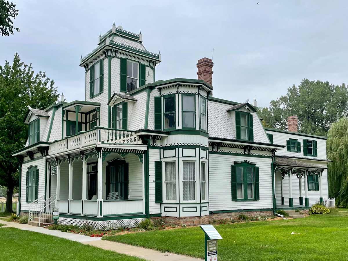
US-26 led us to our first stop in North Platte, Buffalo Bill’s Scouts Rest Ranch (above). I had recently read a book entitled Buffalo Bill and the Mormons, and I was interested in seeing where the man had lived for much of his life. See my blog posts on July 26, 2026, and August 2, 2026, for details.
Because of my missed turn earlier, we had to hustle to get to the ranch (a Nebraska state historical park) before its 4 PM closing time – only to learn later that the ranch was not open on Mondays and Tuesdays (i.e., that day). I was, however, able to walk around the building and grounds for a bit and take a few pictures. Shucks!
Travel Tip: Make sure that any attractions you wish to visit are open on the day(s) that you will be there.
During my brief visit, I got to see “SCOUT’S REST RANCH” in bold letters on the red barn. Cody put the name there so that the people of North Platte would see it. I could also see evidence of the irrigation system that Cody had installed on his property, a harbinger of what he would later try to build (with the help of the Mormons) in the Bighorn Basin, along the Shoshone River, near Cody, Wyoming.
The next stop was the nearby Golden Spike Tower, which looks over the busiest railroad hump yard in the world – the Union Pacific Bailey Yard in North Platte. The views from the 7th and 8th floor are great (if you are a railfan like I am). The yard’s statistics are “wow” (2850 acres stretching over 8 miles, 200 tracks totaling 315 miles, 985 switches, an average of 139 trains and 14,000 railcars a day).
Buffalo Bill and the Railroad: Buffalo Bill had a lot of interactions (good and bad) with the railroad. Scouts Rest Ranch lies less than a mile north of Bailey Yard, just off Buffalo Bill Road, which crosses the yard and the tracks. Buffalo Bill got his name hunting the buffalo that fed the workers that were building the transcontinental railroad. Buffalo Bill lived in North Platte, partly because of its location on the railroad, which he used to transport his show throughout the nation. But, in the end, the railroad (i.e., a railroad accident) put him out of business.
According to a sign at Scouts Rest Ranch, “In October 1901, Cody’s train pulled out of Charlotte, North Carolina, around midnight, headed north on the single track main rail line. Unaware that Cody’s entourage consisted of three separate trains, the engineer of a southbound freight train pulled onto the track after the first Cody train passed. The head-on collision killed 92 of Cody’s 110 trained horses. While ‘Buffalo Bill’s Wild West’ returned to the road more than a year later, it was never the same.”
DAY 9 – Back Home to Omaha
The goal of the day was to get home – slowly (via a side trip) or quickly.
Our original plan was to take US-136 along the Nebraska and Kansas border, stopping in Red Cloud to visit the Willa Cather State Historic Site.
At the last minute, as we were heading east on US-30 towards the “decision junction” near Lexington, we decided to forgo Red Cloud and Cather. Instead, we took a more direct route along the railroads – US-30 and the UP to Grand Island and US-34 along the BNSF to Lincoln. From Lincoln, we took I-80 for a few miles before taking US-6 home.
The route change allowed a few extra hours to unpack, pick up the accumulated mail, and buy groceries. I am sure we made the right decision.
Summary
Scenery: The unique beauty of the plains is not appreciated by everyone, but we observed a lot of beauty on our road trip. It is a different kind of beauty than we experienced last year along Lake Michigan. It was the beauty of the Niobrara River Valley near Valentine, the beauty of Fort Pierre National Grassland in South Dakota, the beauty of the Badlands near Medora, North Dakota, the beauty of the isolated Sandhills in Nebraska, and the beauty of the crops ripening along the “roads” most everywhere we traveled (that will eventually feed us). We enjoyed all those views and many others.
Hay: I was overwhelmed by the number of hay bales we saw on this trip. There were literally thousands of them resting along the roads, sprinkled through the fields, stacked in feedlots, or resting on semi-trailer flatbeds on their way to market. Most of the bales were those big five-or-six-foot diameter round bales. Occasionally, we would also see a few of the old-style smaller rectangular bales – which leads me to the only joke that I know.
Joke: Did you know that those circular hay bales are illegal in Colorado? Yup, Colorado farmers think that their cattle should get a “square” meal.
Apology: Sorry about that groaner. I originally heard the joke from our guide as we white-water rafted a Colorado river. For some reason, I found it humorous and more importantly, I can remember the punch line.
Drought: The western half of the United States has been experiencing a long drought. The Colorado River Basin is a mess. Parts of Nebraska were very dry in early summer but have rebounded some of late. North Dakota was in fairly good shape during planting season but has worsened lately. During our trip the worse conditions we saw were in central South Dakota near Pierre, and to the east of Scottsbluff, Nebraska (e.g., dried up lakes). On August 12, 2026, the elevation of Lake Oahe was at 1595.53 feet, 24.5 feet below full pool. The lake was about 65% full, with a falling seven-day trend. The West needs rain/snow badly.
Deer: One of the dangers of driving the back roads of America is the deer that one (literally at times) run into. I tried to keep my eyes focused on the road, shoulders, and woods ahead. I spotted deer lurking ahead twice and managed to slow down and avoid them. As noted previously, we splattered one bird. Other than that, and one minor window chip, the trip was without incident. Thank God!
Synopsis: We had an enjoyable road trip. We drove the Subaru 2368 miles over nine days, using 72.12 gallons of gas (32.84 mpg), at an average cost of $3.89/gallon (due to the war with Iran). The Theodore Roosevelt Presidential Library was excellent. Check it out!